
Coordinate Systems
Observational astronomy is rooted in locating, imaging, and studying a wide variety of astronomical objects, from planets, moons, asteroids, and comets in our solar system, to stars and nebula in our galaxy, and out to other galaxies, galaxy clusters and ultimately the universe as a whole. However, only a very small amount of the objects that can be studied in astronomy are actually visible to the naked eye. For example, fewer than 10,000 stars can be seen unaided without telescopes or binoculars, and that assumes absolutely perfect viewing conditions, zero light pollution, and impeccable eyesight. Contrast that number with the estimated 200 billion stars in our own galaxy; under perfect conditions and with the best eyesight around, humans can only see less than 0.000005% of the stars in our galaxy.
How can we find these other stars and other galaxies through our telescopes that are out there if we can’t see the stars with the naked eye to align our telescopes and binoculars with them? While there are ways to use bright stars to pinpoint the location of some fainter objects, this is unreliable and only addresses the issue for a small number of additional stars, nebulae, and galaxies. To be able to consistently and easily find deep-sky objects and stars in the sky, we need to make use of coordinate systems. There are two main types of coordinate systems that any introductory astronomy student (particularly one in an astronomy lab class) should be comfortable with. These are equatorial coordinates, which give stars relative location to each other on a star globe called a celestial sphere, and topocentric coordinates which give an object’s location relative to the Earth and ground-level. Each coordinate system has its own unique benefits and challenges, and each has an important role to fill in observational astronomy.
24houranswers.com has highly trained tutors with professional experience in using these coordinate systems to observe through telescopes all over the world and educational experience teaching these coordinate systems to countless numbers of students. Don’t go it alone! Let us help you understand how the two systems work, their importance to astronomers, and the useful information about the night sky that they reveal. Further, when you are faced with a problem set or assignment involving coordinate systems in astronomy, let us help – online tutoring and homework assistance are always available.
Equatorial Coordinates
Equatorial coordinates are the bread and butter of astronomers as they talk about the position of stars. In this section we will expand on some of the reasons why they are so valuable to astronomers when studying the sky, but one of the primary reasons is that equatorial coordinates do not change (or more technically only change over periods of years) with time of day, day of the year, or location on the Earth. They are a universal system that can be used by astronomers all over the world.
What do equatorial coordinates do? They give the location of a star or other object on the celestial sphere. A celestial sphere can be thought of as a globe for stars. It is not a real object – a spaceship would not suddenly run into or hit the celestial sphere, for example – but it is a great representation of where stars and other objects are relative to each other, with an important caveat. Two objects located close to each other on the celestial sphere will be found close to each other when looking at the sky. However, this does not necessarily mean that they are close to each other in reality since the celestial sphere does not indicate distance.
Two coordinates are needed to accurately give the location of an object on the celestial sphere: right ascension (RA) and declination (dec). An easy way to think about equatorial coordinates and the celestial sphere is their close parallel to latitude and longitude and the Earth’s globe: Right ascension is similar to longitude while declination very closely aligns with latitude.
Declination. Let’s first discuss declination. Declination, just like latitude on the Earth’s globe, is measured in degrees. Mathematically the declination is defined by the angle between a line running from the center of the earth to the celestial equator and a line running from the center of the earth and the star or object in question. The starting or zero point for declination is a circle running directly around the middle of the celestial sphere. This zero point is called the celestial equator and is in exactly the same place as Earth’s equator is on the globe. The declination of the celestial equator is 0o. As you move away from the celestial equator to the north, the declination increases. The maximum value for declination is +90o and occurs at the celestial north pole, which is equivalent in concept to the Earth’s north pole on a globe. The minimum value for declination is -90o and is likewise at the celestial south pole, the equivalent of Earth’s south pole. The numbers and measurements for the declination of various spots on the celestial sphere are identical to those of latitude on an earth globe with one minor difference. For the Earth, we say that the latitude north of the equator is so many degrees north and the latitude south of the equator is a certain number of degrees south. For example, New York City is located at a latitude of 40.7o N and Sydney, Australia is at a latitude of 33.9o S. However, for declination, instead of using North and South we instead use positive and negative numbers.
Applications of Declination. The declination of an object is incredibly useful in determining where it can be found in the sky and what its general motion will be.
Firstly, the declination of a star can be used to figure out whether the star will pass directly overhead (i.e. zenith) for an observer. The rule is that a star will pass directly overhead if, and only if, its declination is equal to the latitude of a person’s location on Earth. North latitudes are treated as positive numbers and south latitudes as negative numbers. For example, London, United Kingdom has a latitude of 51.5oN, so a star with a declination of +51.5o will pass directly overhead in London. Stars with declinations smaller than an observer’s latitude will be found to the south when they transit (i.e. reach their highest point in the sky at that location) while stars with declinations larger than an observer’s latitude will be to the north at transit. A quick example of this rule can also help to identify key connections between the celestial sphere and the Earth’s globe. Where do you have to go on the Earth for the celestial equator to be at zenith? The declination of the celestial equator is 0o, so if the celestial equator is overhead then your location must have a latitude of 0o, which is Earth’s equator. In other words, the celestial equator is directly overhead for an observer at the Earth’s equator. Similarly, Polaris, the North Star, is very close to a declination of +90o, which means it is overhead at a latitude of 90oN, also known as the North Pole.
Secondly, declination can be used to estimate how long a star will be in the sky and to compare two stars to determine which will be in the sky the longest. For observers in the Northern Hemisphere, the rule is that the larger the declination, the longer the star will be in the sky each 24 hour period. Note this doesn’t necessarily mean the star will be visible, as it could be in the sky during the daytime, but it will nevertheless be above the horizon. When dealing with negative declinations, think of them as numbers on a number line. Whatever is farthest to the right is the larger number and will be in the sky the longest. So, for example, a star with a declination of -15o will be in the sky longer than a star with a declination of -30o, since -15 is larger than -30. As a baseline to get a very rough estimate of how long stars will be in the sky, stars with a declination of 0o will be in the sky exactly 12 hours each day, no matter what location on Earth you are observing from.
Finally, an observer’s location on Earth greatly determines what stars they will be able to see in the sky. For most locations (with the exception of the equator and the North and South Pole), there will be stars that rise and set, stars that never get above the horizon and can never be seen, and stars that are circumpolar, which means they are always above the horizon and appear to be moving in circles around either Polaris or the South Celestial Pole. For every location on Earth, you can calculate the declinations of stars that will fall into these three categories using the following rules for the Northern Hemisphere:
- Stars that rise or set = All stars with declinations > (your latitude – 90) and < (90 – your latitude)
- Circumpolar stars = All stars with declination > (90o – your latitude).
- Stars that are never visible = All stars with declination < (your latitude - 90o)
For example, in the Table below we give the declinations for circumpolar stars, stars that are never visible, and stars that rise and set for four locations in the northern hemisphere.
|
|
Stars that rise or set |
Circumpolar stars |
Stars never visible |
|
Equator (Lat. = 0o N) |
Dec: -90o to +90o |
None (Declination can’t be greater than 90o) |
None (Declination can’t be less than -90o) |
|
North Pole (Lat. = 90oN) |
None |
Dec: 0o to 90o |
Dec: -90o to 0o |
|
San Francisco (Lat. = 38oN) |
Dec: -52o to 52o |
Dec: 52o to 90o |
Dec: -90o to -52o |
|
Oslo (Lat. = 60oN) |
Dec: -30o to 30o |
Dec: 30o to 90o |
Dec: -90o to -30o |
For observers in the Southern Hemisphere the rules are slightly switched:
- Stars that rise or set = All stars with declinations > (-90 – your latitude) and < (-90 – your latitude)
- Circumpolar stars = All stars with declinations < (-90 – your latitude)
- Stars that are never visible = All stars with declinations > (your latitude + 90).
Note that in these situations, a latitude in the southern hemisphere is treated as a negative number.
Right Ascension (RA). Now that we have discussed declination, let’s turn to its partner coordinate Right Ascension (RA). RA is very similar to longitude on a globe. It measures where a star is located around the celestial sphere, much like longitude tells you where around the globe a place is located. A key difference for Right Ascension compared with longitude is that RA is measured not in degrees but in hours. RA goes from 0 to 24 hours and each hour can further be divided into minutes and seconds. So, for example, Betelgeuse, the famous alpha star of Orion, has an RA = 5 hr 55m 10s.
What an amazing coincidence that RA runs from 0 to 24 hours and that there are 24 hours in a day! It’s not a coincidence at all because RA has a very close connection with time. Two stars that are located 1 hour apart in RA will effectively be 1 hour apart in their motions through the sky as well. A word of caution, however, is in order here. Just because right ascensions look like time on a 24 hour clock, do not try to directly connect them. In other words, just because a star has an RA = 8 hr, that does not mean that it does anything unique or important (ie. rise, set, or transit) at 8am or 8pm on the clock. The times that it does rise, set, and transit change throughout the year as the Earth orbits the Sun. There are many references you can use to figure out what right ascension is transiting at a given moment or at a certain time on a certain day. A good, simple, and to the point website is https://www.localsiderealtime.com/ where you just enter your longitude on the Earth and it will tell you the Sidereal Time, which is another term for the Right Ascension that is transiting at a given moment. If you check this website out you will see that the Sidereal Time increases with time just as on the clock – this is due to the rotation of the Earth every 24 hours which means that different stars transit at different times of the day/night.
Once you know the sidereal time that is at transit, you can figure out the time that any star or object in space will transit. The only additional information needed is the Right Ascension of the star or object. For example, let’s say that it is currently 8pm at your location. From checking the website above, you find that the sidereal time is 14 hrs. That means that any star with a right ascension of 14 hrs will be at transit currently. Now, what time will a star with a right ascension of 15 hrs transit? Since the star’s right ascension (15 hours) is one hour bigger than the right ascension overhead (14 hours), this means the star will transit in exactly one hour, which is 8pm +1 hour or 9pm. Similarly if the right ascension for the star was 12 hours, then the star would transit two hours earlier (since the star’s right ascension is two hours smaller than the sidereal time), which is 8pm –2 hours or 6pm.
If you do not have access to a website or app that will give you the sidereal time at your location, what are your options? It turns out that there is a fairly easy way to do this based on the important fact that the right ascension overhead at a certain time increases on average by 2 hours each month or 4 minutes each day. Once you have a starting point then you can estimate the sidereal time for a different time of day or day of the year. The simplest starting point to remember is 0 hours. 0 hours will be transiting at midnight (i.e. will be the local sidereal time) on September 20th. There is some variation on this based on your location within a time zone, how recently leap years have occurred, etc. but it is pretty accurate. How does this work? Let’s say we wanted to find the sidereal time for 2pm on November 20th. Since November 20th is 2 months after September 20th, that means that the sidereal time at midnight will be 0 hrs + 4 hrs = 4 hrs. The 4 hrs comes from the fact that every month the sidereal time at midnight increases by 2 hours, and since 2 months have passed that amounts to 2 hours x 2 months = 4 hours. Since 4 hrs transits at midnight and we are interested in 2pm, then we have to add 14 hours since 2pm is 14 hours after midnight. This gives us 4 hrs + 14 hrs = 18 hrs for the sidereal time at 2pm on November 20th.
On a side note, how is 0 hrs right ascension defined in the first place? 0 hrs right ascension is defined as the right ascension of the Sun at the moment of the Vernal Equinox, the first day of spring. How is the Vernal Equinox defined? It is defined by the moment the Sun is at 0o declination, moving from negative declinations to positive declinations. Due to precession the location of the Sun on the celestial sphere at the Vernal Equinox slowly changes over a 26,000 year cycle, which means that equatorial coordinates for stars do slowly change. Typically every 50 years the equatorial coordinates for stars are updated. Currently coordinates set for the year 2000 are used, with the previous coordinate set being 1950 and then 1900 before that.
Usefulness of Equatorial Coordinates. Equatorial coordinates can be incredibly useful if combined with the proper tools to interpret them. Part of their usefulness lies in the fact that they do not change, or at least do not change from day to day or year to year. Location does not matter. Time of day or day of the year do not matter. The equatorial coordinates for a star stay the same. In previous centuries, telescopes were designed to incorporate equatorial coordinates and how to use them to find stars. Now, computers and automated telescopes are excellent at accurately calculating a local sidereal time and using that to determine the location of a star at your location and time of day and day of the year based on the equatorial coordinates. This is somewhat akin to the skill that a computer or Global Positioning System (GPS) has in determining the direction that a person needs to go to get to a certain place on the Earth.
Drawbacks of Equatorial Coordinates. The fact that equatorial coordinates do not change with location or time of day or day of the year can be a strength but also a detriment. It is much like the situation with latitude and longitude. If a friend gives you the latitude and longitude for their house and then says, “Find it!”, you will likely have problems. How to get to a particular latitude and longitude changes depending on where you are located on the Earth. If you have access to a computer or GPS, however, then the coordinates can be plugged into the computer and it can easily generate the directions needed. Similarly, if I tell you the equatorial coordinates of a star and ask you to find it in the sky or point your binoculars or non-automated telescope at it, you could well run into trouble. A computer or automated telescope can take the equatorial coordinates and give you the location of the star, but on your own it is very, very difficult to figure out where to look to actually see the star. There is need for a different coordinate system that focuses on where to look to see stars in the sky.
Topocentric Coordinates.
Topocentric coordinates give the location of a star in the sky, not on the celestial sphere. These coordinates are incredibly useful in describing where to find a particular star or object and also very simple to understand and use. However, there are some drawbacks to these coordinates which we will discuss at the end of this section. The two coordinates for topocentric coordinates are altitude, which describes the angle of a star or other object above the horizon, and azimuth, which describes the direction the star is located in terms of degrees on a compass.
Altitude. The altitude of a star or other object is defined as the angle of that star above the horizon. The horizon can simply be thought of as ground-level – the point in space directly out in front of you. You can also see what horizon means by imagining going to the beach and staring out over the ocean. That point in the distance straight in front of you where it seems that the sky and water come together is the horizon. Stars, when they rise or set, are found at the horizon and so have an altitude of 0o. Altitude ranges from 0o at the horizon up to 90o at zenith, which is the point in space directly over your head. You will never have an altitude greater than 90o, and although some online programs will give you altitudes that are < 0o, in reality altitude is never negative either. These computer programs interpret a negative altitude to mean one that is below the horizon and not currently visible in the sky.
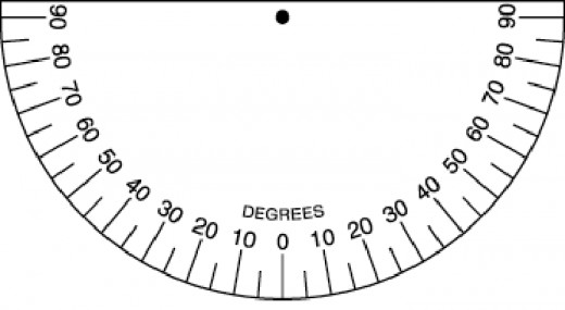
How can you measure the altitude of an object? While there are apps that can achieve this on iOS devices, most of them are not free apps. There are low-technology ways, however, to quickly measure a star or other object’s altitude. This webpage: https://usercontent1.hubstatic.com/5843838_f520.jpg contains a printable version of a device called an inclinometer. It looks like a variation on a basic protractor, which is exactly what it is. To use this device, print it out (preferably on thicker card stock type paper). Next, hang a paper clip or string down from the black circle in the middle of the inclinometer. Be sure to hang it so that the paper clip or string can freely move. Now, hold the paper vertically so that the string or paper clip can freely swing back and forth. Next, look across the top of your piece of paper (i.e. along the straight line part of the semi-circle), so that you are staring directly at the star or object in question. See what number the string or paper clip hangs down at and you have measured the altitude for the object. A second way to measure the altitude of a star or other object is less precise but requires no tools at all. It builds upon the idea that you can use your hand as an estimator of angular size and distance. If you hold your hand out arm’s length in front of you, then the angular distance across the knuckle of your pinky finger is about 1o, across the knuckle of your thumb is about 2o, and across all the knuckles of your fist is about 10o. Now, simply start with the bottom of your fist straight out at the horizon and count the number of fists, thumbs, or pinkies necessary to get to your star or other object and that gives you the angle of the object above the horizon, which is the altitude. So, for example, if it took 2 fists and 3 thumbs to measure from the horizon to a star, then the altitude is 2 x 10o (for the two fists) + 3 x 2o (for the three thumbs) = 26o. Is this method perfect? No – different people have different sized hands, but as long as you hold your arm at full length in front of you then it is fairly accurate, since people with larger hands tend to have longer arms.
Application to Polaris. The location of Polaris, the North Star, in the sky depends on your location on Earth, particularly your latitude. Polaris is directly overhead (i.e. at zenith) at the North Pole and at the horizon for an observer at the equator. The rule of thumb for the altitude of Polaris is that the altitude of Polaris equals your latitude on Earth. For example, the North Pole has a latitude of 90oN, which means that Polaris will be at an altitude of 90o, which is zenith. Seattle is approximately at 47oN, which means that Polaris will be at 47o altitude, or a little more than halfway up the sky.
Azimuth. Simply knowing how far up in the sky a star or other object is does not fully tell you where it is located in the sky. Specifically, it does not tell you what direction to look. The direction component of topocentric coordinates is called azimuth. Azimuth goes from 0 to 360o and exactly mirrors the degrees on a compass. Exact or Due North is 0o, Due East is 90o, Due South is 180o, and Due West is 270o. Directions in between the cardinal directions can be indicated with numbers in between the azimuths of the cardinal directions.
Measuring azimuth is simplest using a compass. With built-in compasses on most phones, all an observer has to do is open the compass app, hold the phone flat in the palm of their hand, and point it in the direction of the star. Whatever number the compass shows is the azimuth for that star or other object. Some compasses will attach directions like N, NE, etc. to the number. However, only the number matters and not the letters because azimuth can be most accurately indicated by the azimuth and not a general direction. An actual magnetic compass can be used to achieve the same measurement. However, keep in mind that the Earth’s magnetic pole is not precisely at Earth’s physical north pole, so unless this discrepancy is accounted for, a magnetic compass will not get as accurate a measurement of a star’s azimuth.
Benefits and Drawbacks of Topocentric Coordinates. Topocentric coordinates are incredibly useful in describing where an observer found an object in the sky. Additionally, they are much simpler to calculate for a star that you find in the sky than equatorial coordinates are. The main drawback, however, of these coordinates is that they are not universal. Since stars move in the sky and since observers at different locations observe stars at different places, the topocentric coordinates of a star change with time, date, and location on Earth. Therefore, if a friend tells you to look at a certain altitude and azimuth to see an interesting star or other object in the sky, you must ask them to clarify not only what day and time you should look but also from what location you should try to find the star or object at those coordinates.
Conclusion.
Coordinate systems are incredibly beneficial in describing where a star is located on the celestial sphere and in the sky. Knowing how to quickly interpret these coordinates is vital to being a good observer and being a good astronomer. Here at 24houranswers.com we are ready to help you learn how to measure coordinates, interpret coordinates, and become a better astronomer! Don’t struggle on your own – let us help you!